

Monarch's Way - An Introduction to a 625 mile footpath
Monarch's Way T shirts and Hoodies
Monarch's Way Guide Books & Badges
Maps & Postcards of the Monarch's Way
Cotswolds Guide Books & Maps of the Monarch's Way
Warwickshire - The Monarch's Way
Temporary Amendments to The Monarch's Way
Places to Visit along The Monarch's Way
Walks Around The Monarch's Way
Bird News along The Monarch's Way
Amanda's Charity Walk Ham Hill to West Bay
Oak Apple Day 29th May 2012 Guildhall Worcester
Changes to the Route of the Monarch's Way
Minder's at work along the Monarch's Way
Trevor's Boot Relay Pictures part 2
Trevor's Boot Relay Pictures part 3
Trevor's Boot Relay Pictures part 4
Trevor's Boot Relay Pictures part 4A
Trevor's Boot Relay part 5 Book 2
The Monarch's way Relay part 8 (updated)
The Monarch's Way Relay part 9
The Celebration into Charmouth-Trevor's Boot Relay part 10
The Monarch's Way Relay part 11 Book 3
The Monarch's Way Relay Part 12
The Monarch's Way Relay part 13
The Monarch's Way Relay part 14
|
Amend 01. Book 3. Section 43 Broadwindsor to Winyard's Gap pages 11-13 With the publication of OS Explorer 116, it is possible to be sure of the public status of the “white road” shown as Common Water Lane between GR 448028 and GR 470033. This has the effect that the cattle pens at West Dibberford Farm and the busy A3066 can be avoided by following this new route - a sketch map and new narrative follows.
Delete from “Go Left...” immediately after “Private Lake & Surround”, in line 9 of the first paragraph (page 11) to, and including, “in front” in line 6 of paragraph 2 (page 13) and substitute: “Ignore the gate to the lake and continue forward along the unsurfaced green lane which you now follow for 1½ miles (with good views) until reaching a minor road. Go right along this road for ½ mile when you will come to a signed, crossing bridleway. Go left with the signpost, over a cattle grid and initially follow a farm road. In a little while the farm road turns sharp left while you continue forward and down on a waymarked green lane- which can be muddy at times and in places. Follow this bridleway eventually through woodland until arriving at two hunter’s gates enclosing a crossing bridleway. Go through the first gate and then turn right to follow the other bridleway where immediately in front of you are two gateways”
|
|
|
Due to substantial development within the centre of Yeovil it is necessary to modify the Way slightly. At page 22, 4th paragraph alter to read: “where all the paths merge. Here continue forward on a wide track – with the canalised stream on your right – until you reach a large leisure and commercial complex. Here go forward on a new cycle/pedestrian footpath with the new buildings on your left and follow the canalised stream (on your right) until the cycle/pedestrian path turns left to then meet a road bridge crossing over the car park road. Here turn right underneath the bridge and follow the path around the edge of the extended car park to enter the Yeovil Country Park near its notice board. Here there are wooden steps up on the left which you go up to a kissing gate. Go through into the field and now walk half right up and across the slope to reach the inverted corner and another kissing gate. Pass through this to go left, between buildings and houses, to then execute a quick right and so, on a path, pass in front of houses and then down steps onto the A30.” The text in normal type is the existing and the italic is the new text. After “the A30” just continue with the second paragraph on page 23. |
|
| Amend 03. Book 3 Section 46. Trent to Horethorne Pages 26-27 Now that we can be sure of is public status this alternative route avoiding the 500 yards walk along the B3148 can be offered. Although the route follows more tarmac road walking than the route originally described it is less and as a such you may wish to follow it. The description now follows: At the B3148 turn left and then immediately right (carefully crossing the road along the surfaced drive to Coombe Farm. In a short way the drive turns right where you leave it to continue forward on a unsurfaced hedged green lane/track (Coombe Lane). Follow Coombe Lane for the for the best part of mile to reach a junction with a surfaced lane (Bowden Hill) and another surfaced lane opposite – there is also another golf course opposite. Here turn left and follow Bowden Hill down for about ¾ mile, passing the unsurfaced Moorway Lane on the left, to reach the right junction with the Post office letter box and “no through road” sign. Continue with the existing route description “Go right here ....” |
|
|
|
|
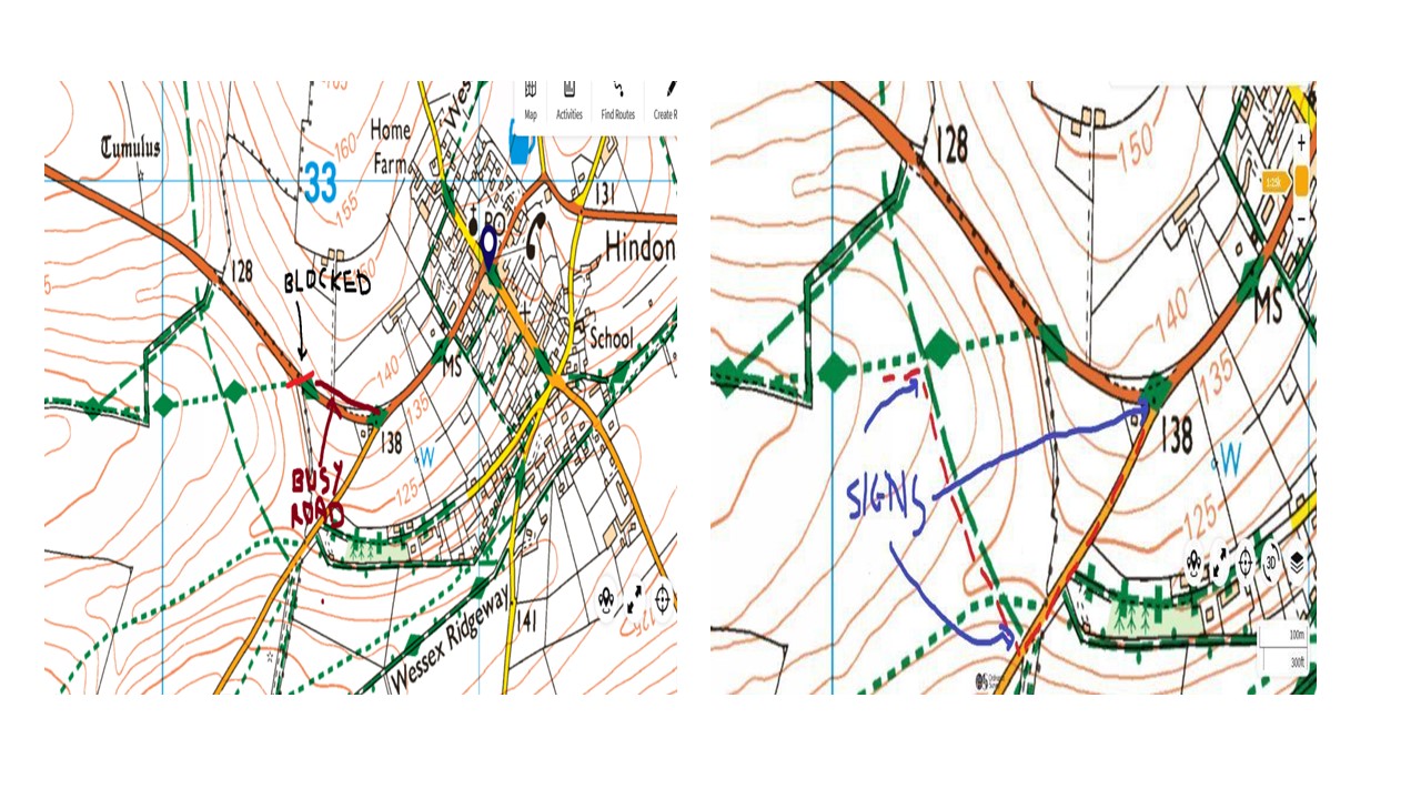
| Amend 04. Book 3 Section 49. Mere to Hindon Page 41 Paragraph 3. Background Historically the last part of the route as the map below shows has always been difficult. There has been a lack of signage possibilities and the banking has been overgrown with bushes and trees. The exit onto the road is tricky and the walk along the road is dangerous as there is no grass verge and the traffic moves very quickly. New Route The Minder of the section has had Discussions with the land owner and this has created good opportunities. I am very happy with the new route which is shown below. It follows the Red Line and Waymarker posts and signage will be installed as shown on the map. It’s a much safer route for walkers still on a public right of way and has the support of the land owner.
Please substitute the following for the original paragraph: As a consequence we now suggest that you turn right along the grassy track and follow it the short distance to a tarmacced lane. On the lane go left and follow it up to the B3089. At the road go right and follow it into Hindon and the Grosvenor Arms (The Angel Inn), the end of this stage.’
|
|
 |
|
| Amend 05. Book 3 Section 50. Hindon to Great Wishford Pages 42 and 43. Delete from paragraph 4 on page 42: ....’At the road turn right………’ all the way to the end of the italics on page 43 and insert…….. |
|
|
|
|
| Amend 06. Book 3 Section 56. Owslebury to Warnford pages 71 -72 With the publication of OS Explorer 119 & 132, it is now possible to be sure of the public status of the “white road” that joins Stokes Lane at GR 564215. This has the effect that the bending, short section of road referred to in the penultimate paragraph of page 71 is avoided by an attractive new route- a sketch map and new narrative follows. "When you are at a point just before the bottom of the field a path goes off to the left and towards a solitary bush and water trough. Ignore this path to continue your forward line down and up to a stile in the fence a short distance ahead. Over this go very slightly left, up a slope, to step stile in a line of trees and a fence. Crossing the stile continue forward initially with a right fence, across a field towards a hedgerow some distance ahead. Some little distance before the hedge/fence swing left with the track and then at the end of a corrugated barn swing right to pass between the barn and a house and so onto a lane. |
|
|
|
|
| Temporary Closure along the Riverside out of Arundel until 1st September 2018 Passing the cathedral follow the road down to a Give Way sign and T-junction which is near an entrance gate to the castle. Cross over and continue forward into High Street. At the war memorial take the left fork in the High Street to quickly meet a mini-island. Cross over the road into Queen Street opposite, which immediately takes you over the river bridge.
Do not go left along to the River Side as it is closed. Instead continue forward on the footpath by left hand side of the Queen Street. Half way along cross the right hand side of Queen street to continue with the footpath. , that leads to the A27 at the roundabout heading out of Arundel Just before the roundabout cross over the right hand side of Queen street to take the A27 out of Arundel. Continue along the footpath along right hand side of the A27. until you come to a light controlled pedestrian crossing before the the Railway station. At that point cross over the A27 and walk on the right hand side footpath over the railway line bridge.
Continue forwards until you reach a sign road sign for (Warningcamp, Wepham, Burpham) pointing down Cross bush lane. Before reaching Cross Bush Lane cross over the road at to central reservation pedestrian crossing onto path just before corner of Crossbush Lane. Then turn into the lane. Continue along Cross Bush lane until you reach the point where the MonarchsWay meets the lane having crossed over the railway line first .
Continue along the road (which is signed for Burpham and also as a ‘no through road’ for buses) and in a ¼ mile arrive at a public bridleway sign on the right. Go right with the sign through the gap at the side of the bar gate where there is also a sign ‘The Angmering Park Estate’. |
|
|
|
|
|
|
|
|
|
|
Page Updated 622nd February 2024 |
|